We have already came across the Huts at the Sub-Antarctic Macquarie Island (WAP AUS-Ø8), on last april 2019, see: http://www.waponline.it/a-quick-tour-among-the-huts-at-macquarie-island/.
Today we’ll have a brief tour through the historical Huts on the same island:
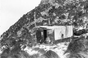 Historic Old Sandy Bay Hut Everyone on the island, and all the tourists who visit, are familiar with the little old field hut at Sandy Bay. It is solid as a rock and banded with rusty iron, tussocks grow on top and roosting skuas keep watch over the surrounding king penguin colony. It is a picturesque sight.
The door bolt is rusted shut, but expeditioners can peer in the grubby window at a dark, decrepit interior festooned with penguin-moult feathers caught up in spider webs – very atmospheric. Feathers from moulting penguins can be found everywhere, as we know from doing our weekly communal clean-up duties. It is amazing how they can sneak through the tiniest crevices in buildings.
Historic Old Lusitana Bay Hut
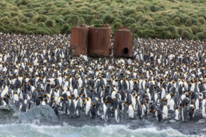 The little old Hut at Lusitania Bay (54° 42′ South, 154°50′ East) just north of the king penguin colony. The huts are old Walrus aircraft engine packing crates, put in place in 1949. They served as field huts for many years and still could have, no doubt, except that the king penguin colonies at Sandy Bay and Lusitania Bay overtook them both and they were abandoned in favour of the new huts at Brothers Point and Waterfall Bay. (pic aside show Lusitania Bay’s penguin colony)
Other Huts at Macquarie Island
Huts and try works were located at the Isthmus, Sandy Bay, Lusitania Bay, Caroline Cove and Hurd Point. Russian explorer Thaddeus Bellingshausen visited Macquarie Island in 1820 and reported that a total of 40 men were working on the island. He also left an interesting description of the sealers hut at Sandy Bay which was:
20 feet long by 10 feet broad, inside it was lined with skins of seals, the outside was covered with a kind of grass which grows on the island. At one end was a small hearth, and a lamp was always kept alight. … Beside the hearth was a bedstead. Provisions were stored at the other end of the hut. Inside it was so black and dark from the smoke that the smouldering light from the lamp and from the holes in the wall over which bladders were stretched, scarcely lit the interior of the hut, and until we got accustomed to the light the sealers had to lead us by the hand.
Let’s have a look to the others removed Huts:
With the long awaited recognition that Macquarie Island was cat free this last season, there was no longer any justification for the presence of the three plateau Field Huts that had been established some years ago to provide accommodation for the Tasmanian Parks and Wildlife staff involved in the cat eradication project, part of the Vertebrate Pest Management Program:
They were:
Mt Eitel Hut (54° 36.6′ South, 158° 50.9′ East),
Lake Tiobunga Hut (54° 41.7′ South, 158° 49.2′ East)
Windy Ridge Hut (54° 44.0′ South, 158° 49.8′ East).
Another Hut was established at Davis Point in 1993 for the purpose of conducting the marine debris survey.
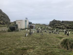 Davis Point Hut (54° 39.9′ South, 158° 49.5′ East) There is a small hut at Davis Point (pic aside) used for special fieldwork and as a refuge, which catches rain water off the roof. Davis Point hut is a cross country transit to Green Gorge Hut
The Davis Point Hut is one of seven shelters dropped across the island for hunters and their dogs tracking rabbits. They were a vital part of the Macquarie Island eradication of pests.
As this work will now be centered on Bauer Bay, there was no longer any need for this hut to remain on the island. Mt Eitel apple hut packed up. Rat-proof cage pallet in foreground. March 2003
When the ship arrived at the end of March, the helicopters were deployed to lift both the Davis Point Hut and the three apple huts from the plateau, by cable sling and transport them back to the main station area. Each hut was accompanied by two pre-packed cage pallets, gas bottles and a black rat-proof cage pallet with perishable items such as food. It took about three to four hours of work to totally remove each of the apple huts and their contents.
All four huts were then transported by helicopter from the Isthmus to the ship ready for return to Australia.
Source: http://www.antarctica.gov.au/about-antarctica/history/exploration-and-expeditions/modern-expeditions/this-week-in-antarctica/2003/macquarie-island2/out-they-come-macquarie-is-field-hut-removal
REFUGES (HUTS)
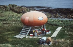 Brothers Point 54° 34.4′ South, 158° 55.1′ East (pic on the right show the Googie Hut at Brother’s point)
Davis Point 54° 39.9′ South, 158° 49.5′ East
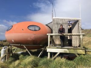 Waterfall Bay Hut (pic on the left) located at 54° 41.5′ South, 158° 51.9′ East
Tiobunga 54° 41.7′ South, 158° 49.2′ E
Windy Ridge 54° 44.0′ South, 158° 49.8′ East
Caroline Cove 54° 45.8′ South, 158° 47.5′ East
Thanks and credit to the following web sites:
http://www.antarctica.gov.au/about-antarctica/history/stations/macquarie-island
http://www.antarctica.gov.au/living-and-working/stations/macquarie-island/this-week-at-macquarie-island/2016/this-week-at-macquarie-island-16-december-2016
http://bazintaz.blogspot.com/2013/11/seven-days-on-island-part-3.html
http://macquarieislandisland.blogspot.com/
 When Argentina celebrates the “Dia de la Patria” our Ham friends of Ushuaia –Tierra del Fuego– WAP ARG-23, did join the event and add the 35th Birthday to the Radio Club Ushuaia LU8XW to it.
 Here, king penguins live in huge colonies. Their days are spent chomping on krill, squid and fish, feeding their chicks and producing ‘guano’, which means poo in penguin. Nothing mind-boggling about that, you might say.
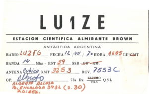
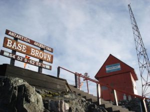 Brown Station (WAP ARG-Ø2) is an Argentine Antarctic Base and scientific research station named after Admiral William Brown, the father of the Argentine Navy.
 During the summer campaign of 1995–96 the Logistics Department of the Argentine National Antarctic Directorate built two new habitable modules: a laboratory and a house with amenities. In the 1999–2000 campaign the Directorate built a new main house capable of comfortably accommodating 8 people; the new building consists of 4 bedrooms, kitchen and 2 bathrooms. Brown slipped into several years of inactivity during the 2000s decade but since 2007 is occupied during the summer again. Paradise Harbor is a large sea inlet southwest of Andvord Bay protected by an arc formed by the Lemaire, Cramer and Bryde islands. Along the harbor’s deep water coast lies the small Sanavirón Peninsula, a rocky promontory crowned by a mound of almost 70 m (230 ft) high called Punta Proa, where the base facilities are located. In the area there are several beacons to help ship guidance: Punta Proa, in the homonymous place; Punta Vidt in General Ricchieri Cove; Punta Conesa, on the entrance to Puerto Leith; Hanka islet on the homonymous place in Paradise Harbor; Punta Piedras in Oscar Cove; and the lighthouse on Cramer Island.
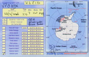 Brown is located 1,100 km (680 mi) from Ushuaia, the nearest port city. As of 2014 the base spans a total area of 1.4 ha (14,000 m2; 150,000 sq ft). It can house a maximum of 18 people. Research programs were developed for biology (zoology and botany), bacteriology, limnology, biochemistry, animal and human physiology, pathology, ecology, oceanography, meteorology, cosmic rays and ionospheric observations, environmental nuclear radiation, continental and sea ice glaciology, satellite geodesy, geology, geophysics, seismology, ozone monitoring and tide measurement.
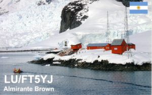 Throughout the years of research and observations at Brown, more than 100 scientific papers were published by the Argentine Antarctic Institute. Thanks to its location on the Antarctica continent along the beautiful Paradise Harbor and to its relatively mild weather, Brown Station is a popular excursion destination for tourist expedition ships visiting Antarctica. In addition to visiting gentoo penguins, tourists may climb to a viewpoint 84 m (276 ft) above the station.
 It’s been 180 years since Charles Wilkes (April 3, 1798 – February 8, 1877) an American naval officer, ship’s captain, and explorer led the United States Exploring Expedition, 1838-1842. He voyaged to the Antarctic continent and his journey has never been more relevant!
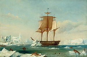 Amundsen might have been the first man to reach the South Pole, in 1911, but the discovery of the Antarctic continent occurred several generations earlier. In January 1840, when Wilkes was commander of the United States Exploring Expedition, he charted 1500 miles of the east Antarctic coastline in his flagship U.S.S. Vincennes (picure on the right, shows the 19th-century painting, based on a sketch by Lieutenant Charles Wilkes, USN, depicting USS Vincennes in Disappointment Bay, Antarctica, circa January–February 1840).
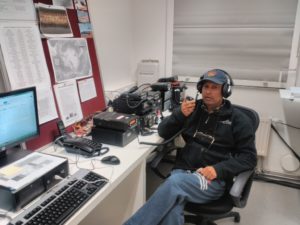 We remind our friend Ham radio Bhagwati Prasad Semwal, VU3BPZ (on the pic aside while at Maitri Base) when reading the article below, which gives our readers an idea on what means a Scientific campaign in Antarctica. Not only a pleasure of a selfy with penguins, not a vacation in a paradise but study, scientific projects, researches and experiments, hard life away from the normal activities at home.
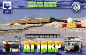 India’s Bharati Station in Antarctica. The continent is home to around 70 active research bases belonging to various countries. These bases house more than 4,000 people during the summer and around 1,000 people in winter. They spend an entire year in isolation, conducting research projects on the icy continent.
 This year, the winter team has 23 members deployed at the Bharati station. It is my responsibility to conduct regular health check-ups to ensure the physical and mental wellbeing of my team mates.
 Amateur radio use in the UK has seen a “significant” rise during the coronavirus lockdown as people seek new ways of staying connected. The national body that represents users – the Radio Society of Great Britain (RSGB) – has said many people who formerly enjoyed the hobby are also returning to it.
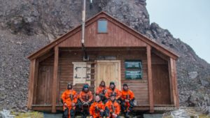 Located on ASPA 128, Demay refuge (wood hut) 62°13’ South, 58°26’30” West, is situated on a flat marine gravel terrace in Paradise Cove between Demay Point and Uchatka Point. The refuge can be reached both by Zodiac and by foot.
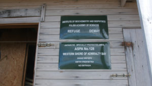 Their memories are preserved in the cottage guest book. The refuge contains two bunk beds, gas cooker, stove and even a shower. There is a VHF radio available with antenna on the rocks above the refuge. It is perfect for hiding from the cold, wind, blizzard and heavy rain. Those who stayed in the Paradise overnight can confirm that few earthy pleasures compare to a dawn on the veranda with a warm cup of tea in hands and a view over a calm horizon decorated with icebergs, waves breaking against the rocks of Demay Head, sleepy elephant seals and playful furseals.
 The little old Hut at Lusitania Bay (54° 42′ South, 154°50′ East) just north of the king penguin colony. The huts are old Walrus aircraft engine packing crates, put in place in 1949. They served as field huts for many years and still could have, no doubt, except that the king penguin colonies at Sandy Bay and Lusitania Bay overtook them both and they were abandoned in favour of the new huts at Brothers Point and Waterfall Bay. (pic aside show Lusitania Bay’s penguin colony)
 Brothers Point 54° 34.4′ South, 158° 55.1′ East (pic on the right show the Googie Hut at Brother’s point)
 Waterfall Bay Hut (pic on the left) located at 54° 41.5′ South, 158° 51.9′ East
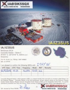 While talking of his Antarctic experience, Marco De Pas (DK5SQX-IK5SQX) is happy for such a great professional and human experience lived in the Icy Continent. -Our LIDAR a kind of optical radar that does “Cloud ranging” works perfectly and that’s great- Marco said!